Day 1 - Thursday, May 29
Left Sylmar at 3:05 am. Saw the sun rise as I was pulling out of
Baker. A couple of hours after that, I was on US-93 heading north, away
from I-15. I stopped for an extended break in Alamo, NV at 8:20, after
traveling for 369 miles. Then I continued north, taking the cutoff through
Hiko on NV 318. As you start on NV 318, there is the warning sign - next
gas 105 miles. I had my emergency bottles, but I didn't need them. I
made it to Ely, which was 146 miles from the last stop at Alamo and took on 4.3
gallons of go juice. It is easy to make time in Nevada, and burn gas,
since the 2 lane highways have a speed limit of 70 mph.  Soon
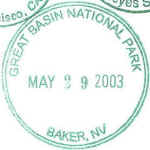
I was at the first stamp stop, Great Basin NP, at 11:35. I had gone 515
miles so far. The stamp at Great Basin is different than the others.
It had a self-inker and was a bit bigger than the normal stamp. I wasn't
sure if I could fit 2 of these side-by-side like the normal stamps, so I put it
in the center of the line. By now, I was along US-6. I still dream
of taking US-6 from the original western terminus of Long Beach, CA, all of the
way to the eastern terminus on Cape Cod, MA. I have done from Long Beach
to Ely, NV. On this trip I will be adding the stretch from Ely to the I-15
in Utah. (See my BunBurner
1500 trip - August 2002 for more on US-6.) I lost an hour as I crossed
into Utah and entered the Mountain time zone.
As US-6 nears I-15, it swings north and goes through the Tintic mining
district. At Santaquin, US-6 joins with I-15 and continues north. At
Springville, US-6 heads east again, but since I was going to Salt Lake City, I
continued north on I-15. I stopped for gas in Provo. It was close to
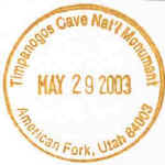
4:00 in the afternoon, and hot. I decided to go to Timpanogos Caves NM today instead of waiting until Saturday as I had originally planned. I
had left about an hour earlier than I originally planned to, and I was making
better time than S&T had estimated. So I was 3 hours ahead of
schedule, plenty of time to get the stamp at Timpanogos. I got off of the
freeway at American Fork, go north through town, and then east to the visitor's
center. I got my stamp and then took a break under the trees. I
headed back to I-15 and then continued north. I hit SLC at rush
hour. Although the stop and go sections of traffic were relatively short
compared to LA, I missed being able to lane split. Soon I was getting off
in Centerville to get to the house of one of the managers at the distribution
center. I arrived at 6:00. Total distance for the day was 847
miles. Riding time was 11 hours and 43 minutes, which meant that I
averaged 72.3 mph. Total time for the day was 13 hours and 55
minutes.
The Revpack Excursion bag worked well. It fits nicely and is hardly
noticable as I am traveling along. And the room in it was great. I
didn't use the extra small bag on this trip.
On to day 3.