![]()
![]()
|
|
|
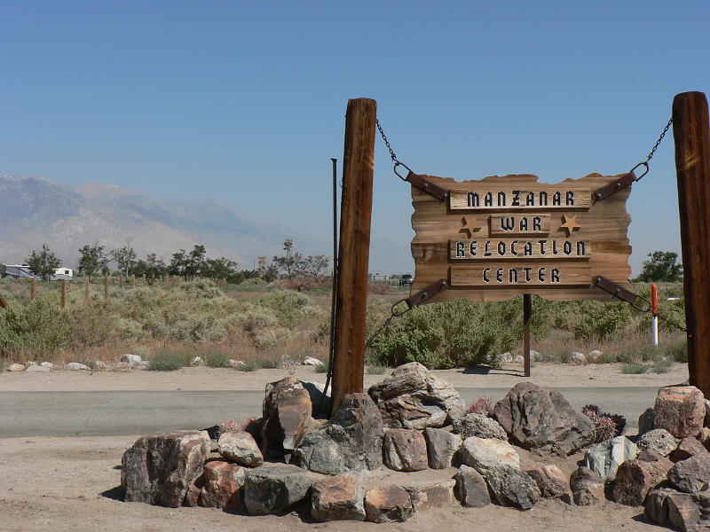
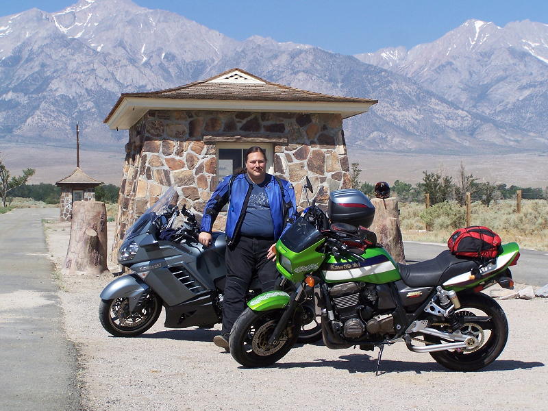
June 28-29, 2008 Planned Trip RW1 (see revised planned trips here) Weekend trip into the Sierra Nevada Mountains. 792 miles. 2 Days. A total of 5 stamps collected. 19 down, 5 to go! Saturday, June 28. I left the house at 6:55 in the morning on Saturday, June 28. A quick stop to top off the gas tank, then it was off to meet Michael at Ave. K & 15 West in Lancaster. As I was dropping down into the Antelope Valley on CA-14, I noticed that there was a smoke haze hovering in the valley, obscuring the slopes of the mountains to the north. The wind was not blowing. The windmills near Avenue S were still. The smoke was from the Piute fire that was burning in the mountains north of the the valley, but south of Lake Isabella. I arrived at the meeting place at 7:37, Michael arrived about 5 minutes later. It was odd to see him on a green bike instead of his usual black 1987 Ninja. The Ninja was having some mechanical issues and would not be up to a long trip, so I let him park the Ninja at my house on Friday and borrow my ZRX for the weekend. We were on our way immediately, traveling north on CA-14, then north on US-395. Not long after getting onto US-395, we made a quick 7 minute gas stop at Pearsonville, leaving at 8:54. As we were traveling up US-395, I was recalling how much of these 2 highways were just 2 lane roads when I started driving in the late 70's. Now, CA-14 only has a small stretch between Red Rock Canyon and Indian Wells that is not 4 lane highway (I think the project to upgrade this stretch is starting soon), and US-395 had a longer stretch of 2 lane near Olancha and Cartago. North of Lone Pine, from just south of Manzanar until Independence, another 2 lane section remains. We reached Manzanar at 9:50 and spent 15 minutes at the historic entrance station taking our pictures for the SCMA passport book, and taking some other pictures. This first picture is looking north from the entrance station. A rebuilt guard tower (there were 8 of them) is visible to the left of the tall tree that is left of the left wooden post. The second picture is of the entrance station, looking west at the Sierra Nevada Mountains. For years, this entrance station was all one saw of Manzanar as they traveled on US-395. The gymnasium that is now the visitor center was used by the county highway department, and was not identified as part of Manzanar. In 1997, the NPS acquired the land for the NHS, and in 2004 the visitor center opened. It was strange to get a photo of two of my bikes so far from the garage. If we had a third person that could have ridden the KLR, I could have gotten all three in front of the entrance station.
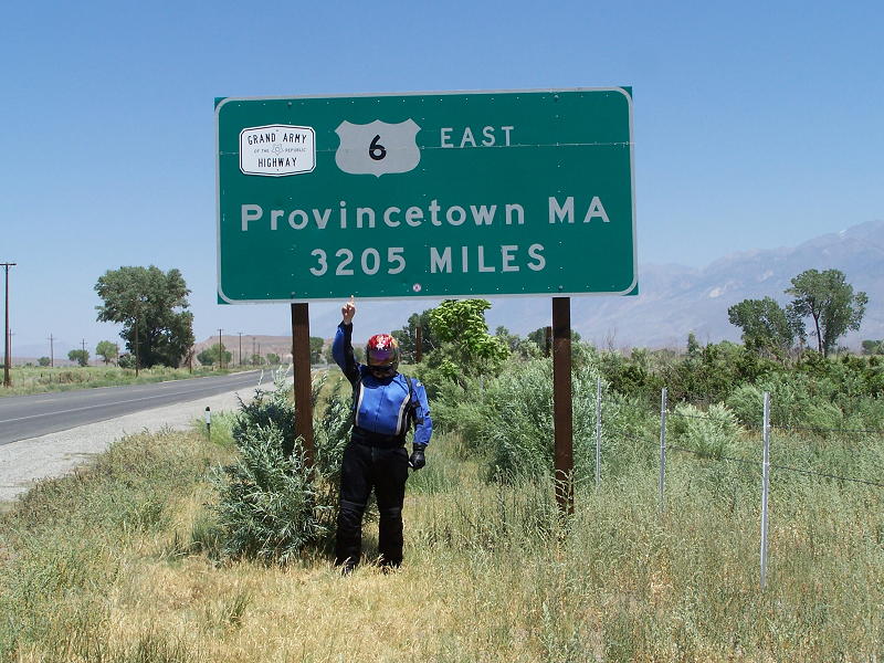
We were at the VC for 15 minutes, getting our stamps. I had been to the VC several times before, and had already did the road tour (dirt roads), and so had Michael. For those that have not been to Manzanar NHS, I would highly recommend it. It is a good example of why we should not shed our rights, or those of others, so quickly in times of emergency. It is sad that in the hysteria after Pearl Harbor, that Americans were locked up in these "relocation centers." We were heading north on US-395 at 10:22 towards Bishop and lunch. There currently is another stretch of 2 lane between Independence and Big Pine. Caltrans was busy at work on this stretch, widening it up to 4 lanes. Lunch was at BBQ Bill's, on the south side of Bishop. It is a quick and decent place to grab a bite. By 11:53 we were heading north again. We did a quick detour to take a photo of the US-6 sign that is just outside of Bishop. My neighbor and I plan to drive all 3,205 miles of US-6 later this summer, along with the historic portion of US-6 that went from Bishop to Long Beach.
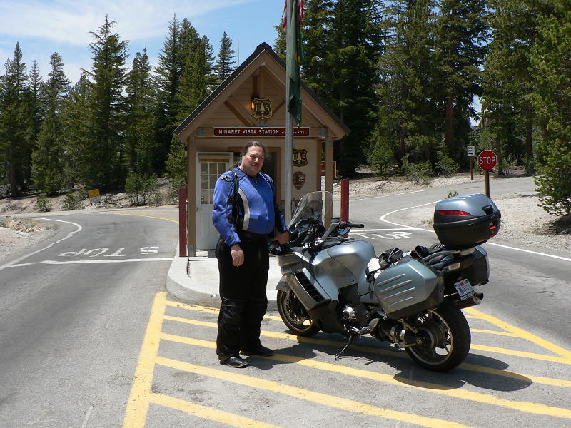
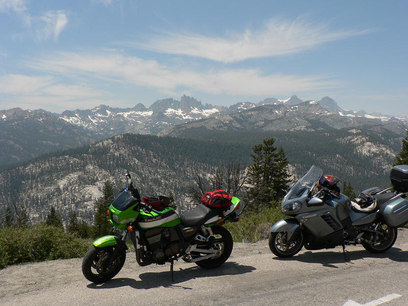
We continued up the grade on US-395, and then turned onto CA-203 into the town of Mammoth Lakes. We stopped for gas in Mammoth at 12:45. Warning - gas in Mammoth is expensive. Fill up in Bishop instead. We continued to the end of CA-203 at Minaret Vista. Michael did try to talk the rangers into letting us ride into the valley and to the NM, but it was not to be. So we took our required photos at the entrance station (first photo below), and then went over to the vista point for another set of photos. The Minarets are the pinnacles in the center of the second photo below.
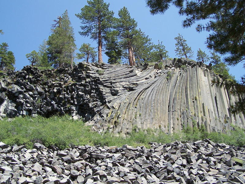
While at the entrance station, I had left my second set of keys in the left saddlebag lock when I went to move my bike out of the way so Michael could get his picture. Getting back off the bike, I hit the key and broke it off in the lock. Bummer. I would have to use either the main key or the emergency key for the rest of the weekend. By 1:20, we had ridden back to the Ski resort upper lodge where the shuttle bus to the valley and more importantly, Devils Postpile NM, leaves from. I extracted the broken bit of the key from the lock, and we took off our gear and stowed them under the Geza covers for the afternoon. We took the shuttle to the NM, got our stamps, and then walked to the postpile itself. I did get bit by a few mosquitoes from the meadow by the ranger station in the postpile parking lot. The postpile is an example of columnar basalt. In the distant past, lava flowed in the region and cooled forming the columns that you see in the picture. Glacial activity sheared the top of the flow off, and water erosion exposed the sides. You can walk to the top of the formation. It looks like paving tiles on top.
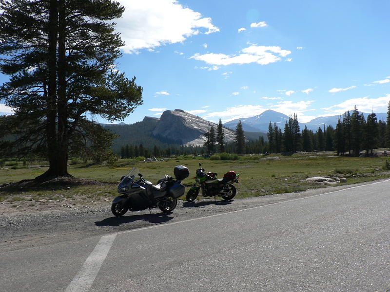
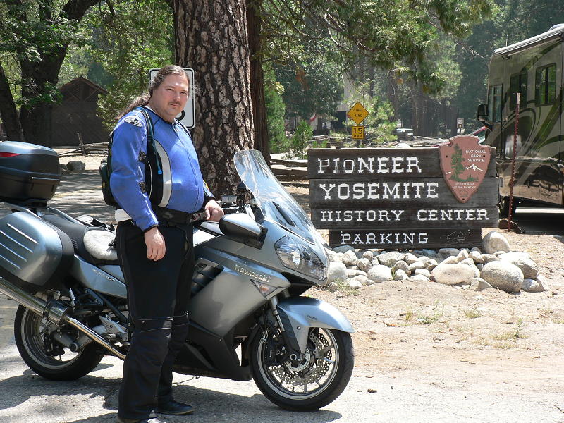
We walked back and waited for the shuttle to take us back up the mountain to the parking lot. We left the parking lot at 4:05, and made it to the motel (Sierra Lodge) ten minutes later. After checking in, we tried to get a replacement key cut at the Do-It center (a hardware store), but they mostly had house keys. I decided to wait until I got back home to get a key made. Michael & I did stop at Chalet Liquors for some evening refreshments. I picked up a few bottles of the local microbrew. We rested a bit and then it was time for dinner. Angel's was just next door, so we walked there and got seated immediately. I have been to Angel's many times before. Great food, decent prices, but sometimes poor service. Many times there is a long line to get in. Arriving at 6:30, we had beat the crowd. After some more relaxing in the motel room, we retired early. It was a nice slow-paced day of 307 miles, but Sunday would be different. Sunday, June 29. We left the motel at 7:50, after having a bagel at the motel's breakfast spread. We needed to get going, since it was many miles of park road at 35-45 miles per hour, and we needed to reach the Sequoia NP stamp location by 5:00. It was a beautiful, crisp morning in the Eastern Sierras. We topped off the gas tanks at the junction of the road to Tioga Pass (CA-120) and US-395, just outside of Lee Vining (also was expensive gas). We reached the entrance to Yosemite at Tioga Pass at 8:35, but then we had to wait 10 minutes in line to get in. The park sign is hard to photograph at Tioga Pass, so we held out for a better opportunity. We made it to Tuolumne Meadows at 8:55. Since the Ranger Station did not open until 9:00, we took some pictures of the bikes by some of the meadows (below), and then got our stamps. Again, there was not a great photo opportunity for the official SCMA passport booklet. At 9:15, we were back heading west on Tioga Pass Road.
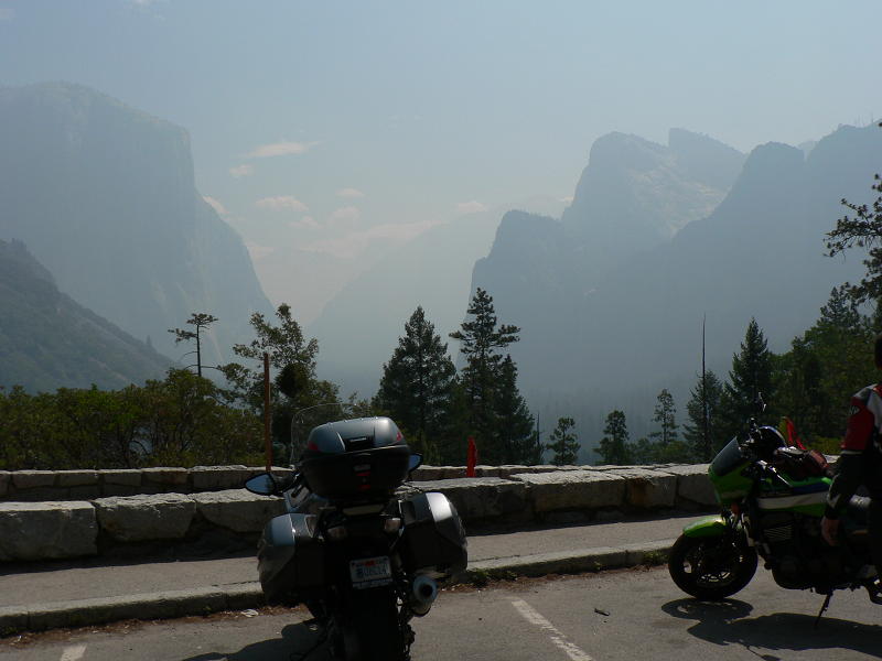
As we got closer to the Big Oak Flat Road, smoke started to fill the air, and the valley to the north, was smoke filled. Most likely from the North Mountain Fire. At 10:08, we reached the junction with Big Oak Flat Road, which was the end of the 45mph roads. It would be 35mph most of the way until the southern exit of Yosemite. We stopped for photos at the Yosemite Valley overlook on Big Oak Flat Road. The valley was filled with smoke. It was hard to see anything in the distance. We made our way down to the bottom, crossed over to the other side, and then started back up the south side of Yosemite Valley. Construction and traffic made me miss the entrance to the parking lot at Tunnel View, and we dove into the tunnel. So we turned around at the west end, and went back through the tunnel. The normally impressive sight of Yosemite Valley when you exit the tunnel was obscured with smoke. Half Dome is barely visible to the left of center in the photo. We left Tunnel View at 10:50, heading towards the southern exit.
We stopped at Wawona for the passport book photos. A good, easy to reach, sign is in the parking lot by the store. We then rode over the hotel parking lot and parked at the cabin where another Yosemite NP stamp is.
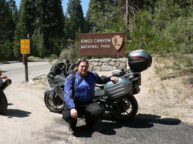
Wawona was only 121 miles from Mammoth, but because of the park roads, it took us almost 4 hours to cover that distance. I had padded the schedule enough to compensate, so we were mostly on schedule. We left Wawona at 11:45, and in a little while we were out of the park, and able to ride mountain roads like a motorcycle should, taking CA-41 south towards Fresno. We stopped for a brief lunch at the Ol' Kettle Coffee Shop in Oakhurst (poor service). In Fresno, CA-41 and CA-180 are freeways. CA-180 ends abruptly at Clovis Avenue, but construction is underway to extend the freeway to a smoother merge with the existing CA-180 (Kings Canyon Road) a few miles east of Clovis Avenue. We stopped for gas at 2:00 along Clovis Avenue, just a block shy of making the left turn onto Kings Canyon Road. 192 miles covered so far. We still were on schedule to get the Sequoia NP stamp before they closed for the day. The ride up CA-180 to Kings Canyon NP was mostly uneventful. We were able to pass several busses in the foothills, so it was smoother riding when the road got twisty and narrow. We made it to the entrance sign for the photos just before 3:00.
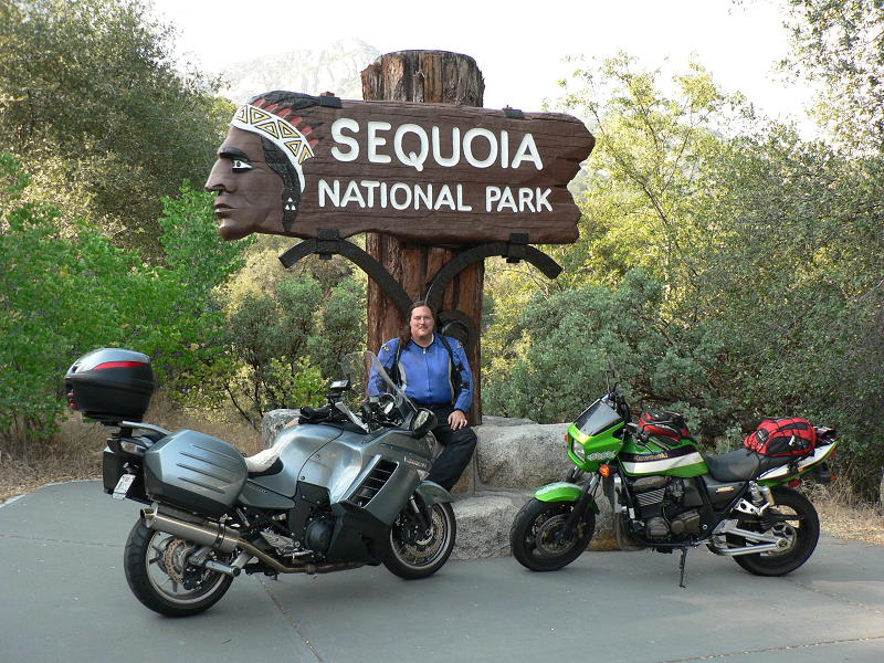
After passing through the entrance station, we continued on to Grant Grove, where the VC there has a Kings Canyon stamp. 243 miles so far for the day. We took a break and had a snack from the general store. Michael also shopped in the gift shop for a spell. We relaxed in Grant Grove for 30 minutes. On the way to Sequoia NP, I looked towards Kings Canyon as we passed the overlook. It was smoky in the canyon. Other than a short encounter with a clueless driver, we covered the 30 miles to Giant Forest at a good pace, arriving at 4:30. I remember years ago staying in cabins at the lodge in Giant Forest. To reduce the impact on the trees, the NPS moved the lodge northward to Wuksachi. They also removed the campground. The former village where there was a cafeteria, post office, and market is now a museum. Since my GPS track log was getting full, I pulled out the laptop and saved the log. We left Giant Forest a little after 5:00 for the ride down the hill. We still needed to get a sign photo, so we pulled over at the sign for the Foothills VC, and spent a few minutes taking photos of the bikes by the sign. A couple of minutes after leaving the VC, we found the real entrance sign, and a deserted parking lot, allowing us complete freedom to position the bikes for several good pictures.
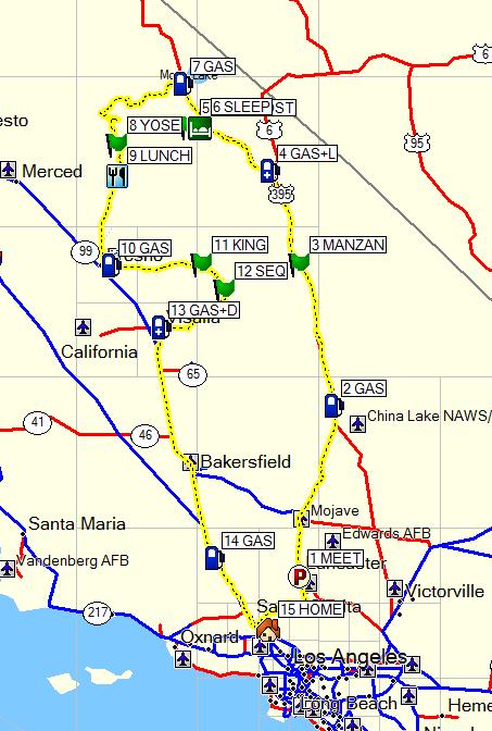
We left Sequoia NP at 6:00, and at 6:40 we stopped at an A&W along Mooney Blvd in Visalia for dinner. At 7:15, we were back in the saddles, continuing south on Mooney Blvd for the 160 mile ride home. A brief stop for gas in Tulare before we got onto the CA-99 freeway filled up the Connie's tank for the ride home. At 9:00 we were in Gorman where Michael topped off the ZRX, and by 9:15 we were going our separate ways. I got home at 9:55, making it a 14 hour day, and the total mileage for the day was 485 miles. GPS Track Log - Pretty much a big loop. #5 is Devils Postpile.
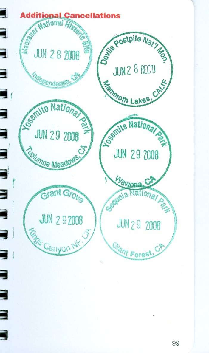
New stamps in the NPS Stamp Book. I have filled up the green region and am spilling over to the extra pages in the back of the booklet.
(note: photos were taken either by myself or Michael Bowman) |